Jakarta, Aktual.com – The Meteorology, Climatology and Geophysics Agency (BMKG) said that based on satellite data earlier this week detected 167 hot spots were on the island of Sumatra with a confidence level of forest fire more than 50 percent.
Head of Data and Information BMKG Pekanbaru stations Slamet Riyadi, said hotspots jumped drastically when compared on Sunday (28/8) yesterday, observed Satellite Imagery United States Space Agency (NASA) as many as 50 points.
“At 06.00 am this morning by the satellites detected 167 hotspots are located in Sumatra. The hot spots are scattered in seven provinces, 86 percent or 145 points including in Riau,” said Slamet, in Pekanbaru, Monday (29/8).
BMKG convey after looking at the distribution of hotspots in Sumatra from the release of the National Aeronautics and Space Agency (LAPAN) based on the monitoring fashionable sensor on NASA Satellite Imagery namely Aqua and Terra.
Six other provinces, he added, which is in South Sumatra, there are eight-point, four-point Jambi, West Sumatra two points, Bangka Belitung, Riau and North Sumatra each of the hot spots.
Slamet detailing as much as 145 hotspots in Riau spread in 10 districts / cities, Rokan Hilir is still the region with the most hot spot concentration of 100 hotspots.
Then followed by the 18 hotspots at Siak, Rokan Hulu six hot spots, Pelalawan and Indragiri Hulu five hot spots, Bengkalis and Kampar four hot spots, Meranti Islands, Dumai and Indragiri Hilir each of the hot spots.
Then, there are seven regions with the number of hot spots was 104, out of the total number of hotspots in Riau is the point of the fire because it has a confidence level of more than 70 percent.
“That is in Rokan Hilir 78 fires, 13 fires at Siak, Bengkalis and Kampar together four hotspots, Rokan Hulu two hotspots, Dumai and Indragiri Hulu each of the hotspots,” he said.
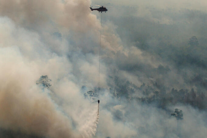
Task Force on Land and Forest Fire (Task Karhutla) Riau Province continues try extinguish the fires with two units flew helicopters and two MI-8 aircraft tractor water in water bombing operations to a number of areas in Riau.
The water bombing operations conducted after the results of air patrols find number of hotspots such as in the area of Rokan Hilir, Bengkalis, Rokan Hulu, and Pelalawan.
Emergency Preparedness Task Force Commander Brigadier General Riau Karlahut Nurendi says, now there is a shift pattern of the burning of land is done by irresponsible persons in the province.
In fact, he said, the hotspots tend to be more and more in the afternoon until the evening, especially on holidays that on Saturday and Sunday.
“We really need to increase enforcement operations for prevention and we have been doing. Until there is one member of the victim, but there are people who still burning,” said Nurendi.
Artikel ini ditulis oleh:


